|
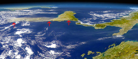
Mt. Etna is Europe's highest volcano
at 10,900 ft (3,516 m). This SeaWiFS satellite image was taken
on Monday October 28 one day after Mt. Etna began to erupt. The
image is taken from the perspective of looking across the Mediterranean
Sea, toward the west - Albania and Greece are beneath Italy's
"heel." The red arrows show the ash plume from the
eruption moving to the south. Lava from the eruption toppled
some ski resort facilities and power lines, but it failed to
reach any of the several towns and villages, which lie all too
close to the flanks of Mt. Etna. Courtesy of NASA. |