
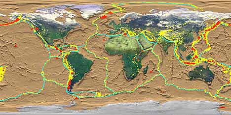
The earth is a dynamic planet. Its rigid outer surface layer is broken into several tectonic plates which are in constant motion relative to one another. As demonstrated in the world map below, most of the ~550 active volcanoes on earth are located along the margins of adjacent plates.
|
World map showing plate boundaries (blue lines), the distribution of recent earthquakes (yellow dots) and active volcanoes (red triangles). Courtesy of NASA. |
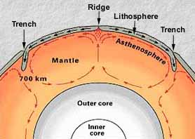
Tectonic plates are composed of lithosphere, the rigid outer portion of the earth. With a thickness of about 100 km, the lithosphere is composed of an upper layer of crust (~7 km thick under the oceans, and ~35 km thick under the continents) and a lower, denser layer of the earth's upper mantle. The lithosphere is underlain by the asthenosphere, a hot, mobile layer of partially molten rock lying within the earth's upper mantle. (For detailed information, click the Earth's Interior.)
 The rigid lithospheric plates are driven by convection within the mobile asthenosphere. Hot mantle rises beneath mid-oceanic ridges, and cold, denser mantle descends at oceanic trenches. Lateral motion of the lithospheric plates above these circular convection cells is analogous to rigid blocks riding above a rotating conveyor belt. Images modified from USGS. |
|
Volcanic eruptions above these lithospheric plates are driven by the ascent of magma (molten rock) from deep beneath the surface. The various magma types are described in Physicochemical Controls on Eruption Style. They vary from mafic, intermediate, to felsic as their silica (SiO2) content increases. Mafic (basaltic) magmas are generated directly from the mantle, either within the asthenosphere or within the overlying mantle lithosphere. Many mafic-to-intermediate (basaltic-to-andesitic) magmas appear to be derived from the melting of hydrated lithospheric mantle. More differentiated, intermediate-to-felsic magmas, on the other hand, are partly derived from the melting of continental crust by hot, mafic magmas that either pond at the crust-mantle boundary, or intrude into the overlying continents where they reside in magma chambers located at various crustal levels.
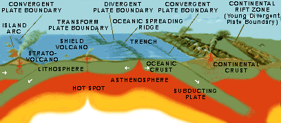
Volcanism is typically widespread along plate boundaries. Although volcanism in the interior of plates is less common, these intraplate regions can also generate voluminous eruptive products. The regional volcano-tectonic processes associated with plate-boundary environments and intraplate environments are described in more detail below.
Plate boundaries mark the sites
where two plates are either moving away from one another, moving
toward one another, or sliding past one another. Adjacent plates
are delineated by three types of boundaries defined by this relative
motion:
- Divergent plate boundaries -- Plates diverge from one another at the site of thermally buoyant mid-oceanic ridges. Oceanic crust is created at divergent plate boundaries.
- Convergent plate boundaries -- Plates converge on one another at the site of deep oceanic trenches. Oceanic crust is destroyed at convergent plate boundaries.
- Transform plate boundaries -- Plates slide past one another.
Although volcanism is abundant at divergent and convergent plate boundaries, there is a distinct lack of significant volcanism associated with transform plate boundaries. Spreading center volcanism occurs at divergent plate margins, and subduction zone volcanism occurs at convergent plate margins. Intraplate volcanism describes volcanic eruptions within tectonic plates. Each of these three volcano-tectonic environments is depicted in the following diagram:
|
Volcanism at divergent and convergent plate margins. Courtesy of USGS. |
For a more thorough description of each volcanic environment, see:
For further discussion on the Earth's interior, see:
 Dr.
Alan Jones at SUNY (Binghamton) has developed an exceptional program
to view historic eruptions and earthquakes in both time and space.
By choosing map regions of specific volcanic environments (spreading
center, subduction, hotspot), you can view the most recent eruptions
as they develop through time. Click the image to download the
program.
Dr.
Alan Jones at SUNY (Binghamton) has developed an exceptional program
to view historic eruptions and earthquakes in both time and space.
By choosing map regions of specific volcanic environments (spreading
center, subduction, hotspot), you can view the most recent eruptions
as they develop through time. Click the image to download the
program.