
The 1980 eruption of Mt. St. Helens is the most studied volcanic eruption of the twentieth century. Although most people were unaware of the potential for such a violent display of volcanism in the contiguous U.S., volcanologists were keenly aware of the potential danger. Months before it erupted, the U.S. Geological Survey (USGS) established a base of operations at Vancouver, Washington to monitor the volcano. On May 18, survey volcanologist David Johnston was camping on Coldwater Ridge, only a few miles north of Mt. St. Helens. The eruption occurred that morning. At 8:32 a.m., Johnston radioed the USGS base and exclaimed "Vancouver, Vancouver, this is it!" The ensuing volcanic blast devastated the northern flank of the volcano, killing Johnston and 56 other victims. At the same time, geologists Keith and Dorothy Stoffel were flying in a light plane only 400 meters above the summit of Mt. St. Helens. From their vantage point, they witnessed one of the largest landslides ever recorded in historic times. Seconds later, a massive explosion shot out the north side of the volcano, toward Coldwater Ridge and Spirit Lake. The explosion generated a billowing cloud with numerous lightning bolts thousands of meters high. The cloud began to expand rapidly toward their aircraft and appeared to be gaining on them, but by turning south they managed to outrun it and survive.
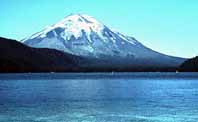 Mt. St. Helen's was known as one of the most picturesque
stratovolcanoes in the Cascade Range before its violent eruption
on May 18, 1980. The eruption generated a massive lateral blast
that devastated the northern flank of the volcano, flattening
millions of mature Douglas fir trees over a fan-shaped area of
600 square kilometers. The blast zone was further subjected to
a huge debris avalanche, followed by the deposition of numerous
lahars and pyroclastic
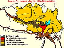
flows. The extent of the blast zone and related deposits
from the 1980 eruption are shown in the map
below. The major physiographic landmarks on the map include the
westward-draining North- and South Forks of the Toutle River,
Spirit Lake, and Johnston Ridge. Spirit Lake is located 5 kilometers
from the summit, as is Johnston Ridge, immediately to the west
of Spirit Lake. Johnston Ridge, previously called Coldwater Ridge,
was named in honor of David Johnston, the USGS volcanologist who
died in the 1980 eruption. Mt. St. Helens was declared a National Volcanic Monument
by an act of congress in 1982.
|
|
|
|
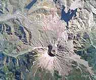
Mt. St. Helens |
There are fifteen subduction-related volcanoes currently active along the Cascade chain. Before 1980, the last one to erupt was California's Mt. Lassen, from 1914 to 1917. In the mid-1970's scientists were concerned that Mt. Baker, in northern Washington, might be the site of the next volcanic eruption, based on increased fumarolic activity on the volcano. However, in 1978, Dwight Crandell and Don Millineaux of the USGS suggested that Mt. St. Helens was potentially the most likely volcano to erupt in the twentieth century. They based their evidence on the relatively young age of the volcano, and its frequent historic eruptions. Mt. St. Helens is less than about 37,000 years old, but it has been especially active over the last 4000 years. Since about 1400 A.D., eruptions have occurred at a rate of about one per 100 years. Before the 1980 eruption, it had been 130 years since Mt. St. Helens last erupted. The style of historic eruptions at Mt. St. Helens was also worrisome. Mt. St. Helens typically generates explosive pyroclastic eruptions, in contrast to many other Cascade volcanoes, such as Mt. Rainier which typically generates relatively non-explosive eruptions of lava.
In 1980, the University of Washington had just completed the establishment of a system of seismometers to help monitor the Cascade volcanoes. The computer feeds for the station went into operation on March 1. The first indications of a major problem came on March 20, when a 4.2 magnitude earthquake was recorded beneath Mt. St. Helens. Three days later another 4.0 M was recorded, and that evening the earthquakes began occurring in swarms centered directly beneath the volcano, at a rate of about 15 per hour. By March 25, magnitude 4 events were shaking Mt. St. Helens at a rate of about 3 per hour. On the same day, several overflights revealed new fractures on the glacier surfaces and a number of avalanches and rockfalls.
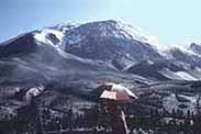
In early afternoon on March 27, a loud explosion was heard from the direction of Mt. St. Helens. Although the volcano was shrouded in clouds, a summit eruption was verified by a news team from the Vancouver Columbian. As they circled the summit in an airplane, they spotted a dense column of ash rising through the clouds to a height of about 2000 m. As the weather cleared later in the day, a new crater was visible, with a diameter of about 70 m, and snow on the summit area was covered by a thin veneer of dark ash. The summit eruption on March 27 was typical of several small eruptions that would occur through April and early May. None of these eruptions were magmatic in character, but instead they were steam eruptions generated by the heating of groundwater above a rising plug of magma that had invaded the central conduit of the volcano.
|
 |
|
|
|
The March 27 eruption generated a huge east-trending fissure high on the north side of the summit. It extended down both sides of the volcano over a distance of about 1500 m. Another, less extensive fracture system had developed farther down the north flank of the volcano, parallel to the higher fracture. Measurements showed that the region between the two fractures had expanded outward to produce a huge north-flank bulge. The bulge was verified by a US Forest Service aerial spotter who reported seeing both fractures open and close as the north flank bulged upward during the hours immediately following the steam eruption.
Several more steam eruptions occurred on March 28, many of which were only a few minutes or an hour in duration. Harmonic tremors and minor eruptions occurred through March and April, with the eruption rate declining from about one per hour in March to about one per day in April. By mid-April, the eruptions had reamed out a new crater, with a diameter of about 400 m. Although the eruptions had declined somewhat in April, earthquake activity continued at impressive rates (>30/day above 3.0M). The epicenters were largely confined to a shallow area beneath the north-flank bulge. The bulge was continually monitored and it got larger and more conspicuous with time. A week before the climactic blast, it had expanded outward by over 100 m and the rate of expansion was about 2 m/day!
The eruption began during a relatively quite period in which no steam explosions had occurred for four days. On May 18, at 8:32 a.m., a 5.0-M earthquake triggered a very rapid series of events. The entire northern slope above the bulge failed and the north flank of the volcano began to slide downward from almost the exact site of the east-west fracture at the summit. This gigantic landslide released a tremendous mass from above the hydrothermal system that had driven the precursor steam eruptions. The abrupt loss of confining pressure above the heated groundwater caused a massive flashing to steam, which initiated a hydrothermal blast that was directed laterally through the landslide scarp. The lateral hydrothermal blast rapidly overtook the avalanche and devastated a fan-shaped area to the north, which was nearly 30 km wide over a distance of 20 kilometers. Trees were blown down like matchsticks.
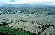
The debris avalanche partly filled Spirit Lake, raising the lake bed more than 60 m and doubling the size of the shoreline. However, the bulk of the avalanche entered the North Fork of the Toutle River and flowed 23 km westward to fill the valley with a craggy and hummocky deposit. The length of the avalanche makes it one of the world's largest ever recorded. The debris avalanche incorporated a significant amount of water, which resulted in voluminous lahars later in the day. These flowed down the North Fork of the Toutle River across the avalanche deposit, and continued downstream as far as the Cowlitz River.
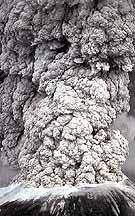 |
THE PLINIAN COLUMN. The avalanche and lateral blast unloaded a large volume of material sitting above the shallow magma source beneath the north-flank bulge. Pressure-release caused the magma to de-gas violently, and within a few minutes a Plinian eruption column began to rise from the former summit. In 10 minutes it had risen to a height of 20 km, where it spread into a umbrella region driven by high-level winds to the east-northeast. Significant ashfall deposits were produced as far as the Great Plains and minor ash was found even much farther east. As the Plinian eruption grew, it continued to ream out the volcanic conduit. The combined destructive forces of the avalanche, the lateral blast, and the Plinian eruption, resulted in the development of a huge amphitheater (1.5 x 3 km) along the volcano's northern flank. |
The Plinian eruption lasted for 9 hours. In addition to airfall, the Plinian phase was associated with numerous pyroclastic flows from column collapse. Most of these were directed toward the north and deposited as pumiceous ignimbrites above the avalanche deposit. Some of these pyroclastic flows extended into Spirit Lake and down the North Fork of the Toutle River. The heat provided by the flows resulted in secondary steam explosions that formed large craters (20m in diameter) with ash columns as high as 2000 m. Smaller magmatic eruptions followed the main Plinian blast on May 25, June 12, July 22, and October 16-18. Each of these subsequent events lasted several hours and produced eruptive columns more than 10 kilometers high.
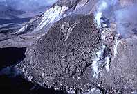
Degassing of the source magma in the underlying magma reservoir resulted in the waning of Plinian-type eruptions. The pastey magma left in the central conduit, and in magma chamber below it, became increasingly less volatile. Shortly after the June 12 eruption, this residual viscous magma began to rise through the vent crater to form a lava dome. The dome was most likely rising into the central conduit even before the June 12 eruption, but was not yet visible. An indication of this is in the nature of the pyroclastic flows associated with the June 12 eruption. Previous flows (on May 18 and May 25) were pumice-rich ignimbrites produced by column collapse. However, the June 12 flows were block-and-ash flows containing abundant non-vesiculated blocks of dense, gray dacite. These pyroclastic-flow types are typically deposited by nuée ardentes, which are generated by dome collapse.
 |
|
|
|
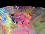
with lava dome |
The dome that began to form on June 12 was partly destroyed by the July 22 eruption, was rebuilt, and then partly destroyed again during the October 16-18 eruption. Thus, after each eruption viscous magma rose up the conduit to build a new dome and replug the vent. In total there were three domes (the first two largely destroyed by the July 22 and October 16-18 eruptions. The dome generated after the October 16-18 eruptions grew at impressive rates through 1983, as demonstrated in a cross-section of dome growth developed by USGS scientists.