
Lahar is an Indonesian term for a volcanic mudflow. These lethal mixtures of water and tephra have the consistency of wet concrete, yet they can flow down the slopes of volcanoes or down river valleys at rapid speeds, similar to fast-moving streams of water. These mud slurries carry debris ranging in size from ash to lapilli, to boulders more than 10 meters in diameter. Lahars can vary from hot to cold, depending on their mode of genesis. The maximum temperature of a lahar is 100 degrees Centigrade, the boiling temperature of water.
|
|
|
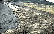
Guatemala (1989) |
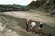
Philippines (1991) |
Lahars are generated by a variety of mechanisms. The majority are produced by intense rainfall during or after an eruption. A tragic example of such an event was the 1991 eruption of Mt. Pinatubo in the Philippines, which was contemporaneous with the arrival of a major hurricane. An estimated 700 people died from buiral by the ensuing lahars, together with the collapse of structures benearth the wet ash. As demonstrated by the graph below, lahars can also be generated directly from a volcanic eruption as massive amounts of water are generated either by the rapid melting of ice and snow, or by the disruption of crater lakes.
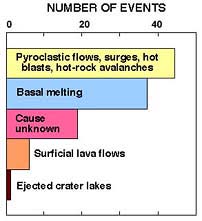 |
This graph demonstrates the number and type of volcanic events known to have produced lahars. It is based on a USGS study of 108 historic eruptions from around the world. Modified from USGS. |
Pyroclastic flows are particularly efficient at generating lahars because they have the capability to melt large quantities of snow and ice in a just few hours. A tragic example of this mechanism occurred in 1985 when pyroclastic flows erupted at the snow-covered summit of the Nevado del Ruiz volcano in Columbia. In only a few hours, the eruption generated a lahar that killed ~23,000 people in the village of Armero and adjacent towns located several tens of kilometers downslope from the summit. Lahars can also be generated by the basal melting of glaciers by lava flows. Basal melting of glacial ice in Iceland has produced largest historic lahars, in terms of discharge. These water-rich, glacial outburst floods are called jokulhlaups.
|
|
|
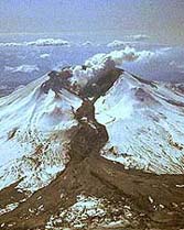
on Mt. St. Helens (1982) |
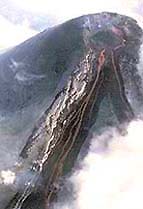
lava tiggers a lahar on the Villarica volcano (1984) |
The snow-covered peaks of the Cascade volcanoes in Washington, Oregon, and northern California pose a clear threat to surrounding towns and villages. Past events suggest that a catastrophic lahar could lie in the future of Mt. Rainier, the largest of the Cascade volcanoes.
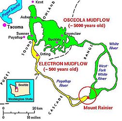 The
4000 m high summit of Mt. Rainier contains the largest system
of alpine glaciers in the Cascade Range. The periodic melting
of glacier ice from Mt. Rainier has generated at least 50 major
lahars over the past 10,000 years. The largest of these mudflow
deposits, one of the world's largest, is the ~5700-year-old Osceola
lahar, shown in the adjacent map (courtesy of USGS).
The Osceola lahar travelled down the White River, over 112 km
from its source. It then spread out at its mouth to cover an area
of over 300 square kilometers along the shoreline of Puget Sound.
The recent geologic history of Mt. Rainier demonstrates that a
major mudflow descends down the White River once every 600 years.
The younger 500-year-old Electron lahar (see map) was also
generated from Mt. Rainier. It flowed 56 kilometers down the Puyallup
River to within 15 kilometers of Tacoma, Washington. More than
300,000 people now live in the area covered by these extensive
lahars! Unlike floods, such catastropic mudflows can occur with
little or no warning. Some volcanologists have predicted that
Mt. Rainier will be the site of the next Cascade eruption. Therefore,
the volcano is monitored closely, with the hope that we can warn
the local population before the next lahar strikes.
The
4000 m high summit of Mt. Rainier contains the largest system
of alpine glaciers in the Cascade Range. The periodic melting
of glacier ice from Mt. Rainier has generated at least 50 major
lahars over the past 10,000 years. The largest of these mudflow
deposits, one of the world's largest, is the ~5700-year-old Osceola
lahar, shown in the adjacent map (courtesy of USGS).
The Osceola lahar travelled down the White River, over 112 km
from its source. It then spread out at its mouth to cover an area
of over 300 square kilometers along the shoreline of Puget Sound.
The recent geologic history of Mt. Rainier demonstrates that a
major mudflow descends down the White River once every 600 years.
The younger 500-year-old Electron lahar (see map) was also
generated from Mt. Rainier. It flowed 56 kilometers down the Puyallup
River to within 15 kilometers of Tacoma, Washington. More than
300,000 people now live in the area covered by these extensive
lahars! Unlike floods, such catastropic mudflows can occur with
little or no warning. Some volcanologists have predicted that
Mt. Rainier will be the site of the next Cascade eruption. Therefore,
the volcano is monitored closely, with the hope that we can warn
the local population before the next lahar strikes.