
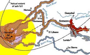
 The Colombian volcano
Nevado del Ruiz is an active stratovolcano with a history of generating deadly volcanic
mudflows (lahars) from relatively small-volume
eruptions. In 1595, a lahar swept down the valleys of the River
Guali and the River Lagunillas, killing 636 people.
In 1845, an immense lahar flooded the upper valley of the River
Lagunillas, killing over 1000 people. It continued for 70 kilometers
downstream before spreading across a plain in the lower valley
floor. The young village of Armero was built directly
on top of the 1845 mudflow deposit. Over the ensuing years, Armero
grew into a vibrant town with over 27,000 residents. On November
13, 1985, history repeated itself for the third time in 400 years,
with another eruption and another deadly lahar racing down the
River Lagunillas. This time, over 23,000 people were killed, including
most of the residents of Armero. With proper planning, this tragedy
could have been averted. Click volcanic
hazards map
for more information.
|
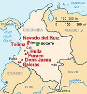
Nevado del Ruiz is the northernmost of several Colombian stratovolcanoes in the Andes Volcanic Chain of western South America. The Andean volcanic belt is generated by the eastward subduction of the Nazca oceanic plate beneath the South American continental plate. Typically, such stratovolcanoes generate explosive Plinian eruptions with associated pyroclastic flows that can melt snow and glaciers near the summit, thus producing devastating lahars. |
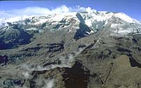 With a summit elevation of 5,389 m (over
17,500 ft), Nevado del Ruiz is the highest of the Colombian volcanoes.
Even though it is located only ~500 km from the Earth's equator,
its high summit is covered with ~25 square kilometers of snow
and ice. Its name, Nevado, means "snow-capped".
During the volcanic outbursts of 1595, 1845, and 1985, large volumes
of meltwater were derived from melting of the ice pack by hot
pyroclastic flows erupting at the summit. Its main crater, Arenas,
lies near the northeastern edge of the ice pack. Because all three
of these recent eruptions were from the Arenas crater, it is not
surprising that the resulting lahars invaded the valleys radiating
northeastward from the summit (see volcanic hazards map).
After nearly a year of minor earthquakes and steam explosions from Nevado del Ruiz, the volcano exploded violently on November 13, 1985. The initial blast began at 3:06 p.m., and two hours later pumice fragments and ash were showering down on Armero. However, the citizens of Amero remained calm. They were placated by reassuring messages from the mayor over radio, and from a local priest over the church public address system. Nevertheless, the Red Cross ordered an evacuation of the town at 7:00 p.m. However, shortly after the evacuation order the ash stopped falling and the evacuation was called off.
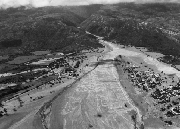
At 9:08 p.m., just as calm was being restored, molten rock began to erupt from the summit crater for the first time (all previous eruptions were steam explosions). The violent ejection of this molten rock generated hot pyroclastic flows and airfall tephra that began to melt the summit ice cap. Unfortunately, a storm obscured the summit area so that most citizens were unaware of the pyroclastic eruption. Meltwater quickly mixed with the erupting pyroclastic fragments to generate a series of hot lahars. One lahar flowed down the River Cauca, submerging the village Chinchina and killing 1,927 people. Other lahars followed the paths of the 1595 and 1845 mudflows. Traveling at 50 kilometers per hour, the largest of these burst through an upstream damn on the River Lagunillas and reached Armero two hours after the eruption began. Most of the town was swept away or buried in only a few short minutes, killing three quarters of the townspeople.
|
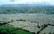
|
|
outskirts of Armero |
center of this photograph |
A few days before the disaster, a Colombian geology student, José Luis Restrepo, had come to Armero on a field trip. After playing billiards, he was returning to his hotel at about 10:50 p.m., when the lahar arrived. His recollection of events were recorded by Dr. Barry Voight:
| "We didn't hear any kind of alarm, even when the ash was falling and we were in the hotel . . . we turned on the radio . . . The mayor was talking and he said not to worry, that it was a rain of ash, that they had not reported anything from the Nevado, and to stay calm in our houses. There was a local radio station and we were listening to it, when suddenly it went off the air . . . about fifteen seconds later, the electric power went out and that's when we started hearing the noise in the air, like something toppling, falling, and we didn't hear anything else, no alarm . . . The priest from Armero had supposedly spoken on a loudspeaker [around 6:00 p.m.] and had said the same thing: that there was no need to leave Armero . . . When we went out, the cars were swaying and running people down . . . there was total darkness, the only light was provided by cars . . . we were running and were about to reach the corner when a river of water came down the streets . . . we turned around screaming, towards the hotel, because the waters were already dragging beds along, overturning cars, sweeping people away . . . we went back to the hotel, a three-story building with a terrace, built of cement and very sturdy . . . Suddenly, I heard bangs, and looking towards the rear of the hotel I saw something like foam, coming down out of the darkness . . . It was a wall of mud approaching the hotel, and sure enough, it crashed against the rear of the hotel and started crushing walls . . . . And then the ceiling slab fractured and . . . the entire building was destroyed and broken into pieces. Since the building was made of cement, I thought that it would resist, but the boulder-filled mud was coming in such an overwhelming way, like a wall of tractors, razing the city, razing everything . . . . Then the university bus, that was in a parking lot next to the hotel, was higher than us on a wave of mud and on fire, and it exploded, so I covered my face, thinking this is where I die a horrible death . . . There was a little girl who I thought was decapitated, but . . . her head was buried in the mud . . . A lady told me, 'look, that girl moved a leg'. Then I moved toward her and my legs sank into the mud, which was hot but not burning, and I started to get the little girl out, but when I saw her hair was caught, that seemed to me the most unfair thing in the whole world." -- from A. Scarth (1999) |
When rescuers arrived at Armero on November 14, they were greeted by a horrible scene. They found tangled masses of trees, cars, and mutilated bodies scattered throughout an ocean of gray mud. Injured survivors lay moaning in agony while workers tried frantically to save them. Altogether, about 23,000 people and 15,000 animals were killed. Another 4500 people were injured and about 8000 people were made homeless. The estimated cost of the disaster is $1,000,000,000, or about one-fifth of the Colombia's Gross National Product.
This is a tragedy that could have been averted. Nevado del Ruiz had served up a steady menu of minor earthquakes and steam eruptions for 51 weeks prior to the November 13 eruption. The on-going activity was just enough to keep people nervous, but not enough to convince authorities that the volcano provided a real threat to the communities surrounding the volcano. Since Colombia had no equipment to monitor the volcano, or geologists skilled in using such equipment, expertise could only come from other countries. A scientific commission and some journalists visited the crater in late February and soon after a report of the volcanic activity first appeared in the newspaper La Patria in early March. By July, seismographs were obtained from several countries to monitor earthquakes which would help in plotting the movement of rising magma beneath the volcano. Money was obtained from the Unified Nations to help map the areas that were thought to be at the greatest risk. The resulting report and volcanic hazards map were finished on October 7, but only ten copies were distributed. Based on the report, the National Bureau of Geology and Mines (INGEOMINAS) declared that a moderate eruption would produce " . . . a 100 percent probability of mudflows . . . with great danger for Armero . . . Ambalema, and the lower part of the River Chinchina." However, some government officials dismissed the report as "too alarming" and authorities did not want to evacuate people until they were assured of the necessity. Continuous earth tremors began beneath the volcano on November 10. This prompted a group of scientists to visit the crater on November 12. However, they saw nothing to suggest eminent danger and they did not recommend an evacuation. The 23,000 people that would die the following day would underscore a tragic failure that led to the second most deadly eruption of the twentieth century.