
Fissure eruptions should not be considered in isolation, because they are also intimately related to Hawaiian eruptions. However, the unique character of fissure eruptions warrants a separate description here.
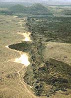
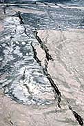 In contrast to the point-source, centralized
eruptions that typify most volcanoes, fissure eruptions are generated
at several contemporaneous sites along a linear fracture, or along
an en echelon (parallel, but offset) fracture system, such
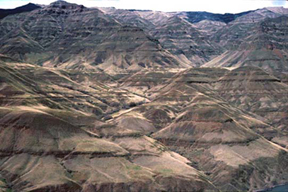
as that shown in the image here. Regional fracture systems can
appear where the Earth's crust is broken and pulled apart by tensional
forces. If these regions are underlain by reservoirs of basaltic
magma, this low-viscosity melt will utilize the fractures and
ascend through the crust to generate a fissure eruption. For example,
Mid-oceanic ridges (divergent plate margins) typically extrude basaltic
magma from fissure eruptions because these are areas where global-scale
extension is coincident with the rise of partially molten asthenosphere. Because Iceland is the
subaerial extension of the Mid-Atlantic Ridge, it is one of the
world's most active sites for basaltic fissure eruptions. For
this reason, fissure eruptions are also known as Icelandic
eruptions. The largest lava flow in recorded history was
generated by a fissure eruption in south central Iceland in 1783.
Known as the Laki flow, it erupted from a 25-kilometer-long
fissure to produce 12 cubic kilometers of lava, filling two deep
river valleys and covering an area greater than 500 square kilometers.
In contrast to the point-source, centralized
eruptions that typify most volcanoes, fissure eruptions are generated
at several contemporaneous sites along a linear fracture, or along
an en echelon (parallel, but offset) fracture system, such
as that shown in the image here. Regional fracture systems can
appear where the Earth's crust is broken and pulled apart by tensional
forces. If these regions are underlain by reservoirs of basaltic
magma, this low-viscosity melt will utilize the fractures and
ascend through the crust to generate a fissure eruption. For example,
Mid-oceanic ridges (divergent plate margins) typically extrude basaltic
magma from fissure eruptions because these are areas where global-scale
extension is coincident with the rise of partially molten asthenosphere. Because Iceland is the
subaerial extension of the Mid-Atlantic Ridge, it is one of the
world's most active sites for basaltic fissure eruptions. For
this reason, fissure eruptions are also known as Icelandic
eruptions. The largest lava flow in recorded history was
generated by a fissure eruption in south central Iceland in 1783.
Known as the Laki flow, it erupted from a 25-kilometer-long
fissure to produce 12 cubic kilometers of lava, filling two deep
river valleys and covering an area greater than 500 square kilometers.
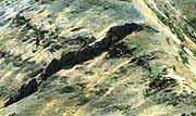
 Fissure eruptions are
also common on the flanks of many large volcanoes and, therefore,
they are not restricted to areas undergoing regional extension.
Magma-filled fissures radiating from the summit regions of active
volcanoes like Mt.
Etna,
Mauna
Loa,
and Kilauea propagate outward from
the central vent system. Extrusion from these propagating fissures
can produce elongate volcano morphologies, such as those that
are typical of many Hawaiian shield volcanoes. Note, for example,
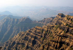
the axial elongation of the Mauna Loa shield volcano shown in the image to
the left. Mauna Loa fissure eruptions are generated along two
axial rift zones connected at the Mokuaweoweo summit crater. Each
rift zone is underlain by magma-filled fissures. The image here
displays several lava flows radiating downslope from these axial
rift zones. Most of these erupted in historic times.
Fissure eruptions are
also common on the flanks of many large volcanoes and, therefore,
they are not restricted to areas undergoing regional extension.
Magma-filled fissures radiating from the summit regions of active
volcanoes like Mt.
Etna,
Mauna
Loa,
and Kilauea propagate outward from
the central vent system. Extrusion from these propagating fissures
can produce elongate volcano morphologies, such as those that
are typical of many Hawaiian shield volcanoes. Note, for example,
the axial elongation of the Mauna Loa shield volcano shown in the image to
the left. Mauna Loa fissure eruptions are generated along two
axial rift zones connected at the Mokuaweoweo summit crater. Each
rift zone is underlain by magma-filled fissures. The image here
displays several lava flows radiating downslope from these axial
rift zones. Most of these erupted in historic times.
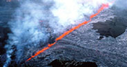
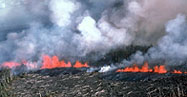
As fluid, gas-poor basaltic magma rises up through a fissure, it is extruded at the surface as a wall of incandescent, liquid-to-plastic fragments known as a curtain of fire. Two such eruptions are shown below from extrusive events on the Kilauea volcano, Hawaii. Fissure eruptions are quiescent, and the height of the airborne eruptive material is small, often only a few tens of meters. The basaltic fragments in the curtain of fire thus remain largely liquid when they hit the ground. These coherent lumps of hot, fluid lava are called spatter. When they land, they can be hot and fluid enough to fuse together to form an aggregate called agglutinate, or agglutinated spatter. Spatter commonly builds up as banks along the fissure sides to produce spatter ramparts.
|
|
|
|
|
|
|
|
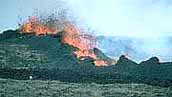
Linear vents with aligned spatter cones and spatter ramparts -- Fissure eruptions will generate a linear system of spatter cones and ramparts. If the eruption becomes concentrated on a single vent, then scoria cones may develop from more explosive Strombolian activity. All of these features are exhibited here from a Neolithic eruption in western Saudi Arabia. |
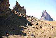
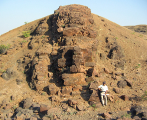
When fissures cease to erupt, the remaining magma residing in the fissure will cool and crystallize into an igneous rock intrusion. The resulting rock structure is called a dike. Dikes are tabular in shape, and they cut discordantly across adjacent rock layers. In areas of ancient volcanism, dikes are often delineated as resistant walls standing above more easily eroded rock types.
|
|
|
Basalt Dike |
New Mexico |
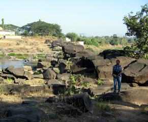
Dikes are often recognized by glassy selvages that develop along their margins where they cool rapidly against the rocks that they intrude, and by contractural cooling joints that generate columnar jointing parallel to their cooling surface, as demonstrated by the two dikes shown here from the Deccan flood basalt province.
|
|
| A 25-km-long dike located northwest of the town of Dhule, India. The dike is one of a swarm of E-W to ENE-WSW dikes in the central Deccan flood basalt province. Photo curtesy of Hetu Sheth. | A 20-km-long dike in the western coastal region of the Deccan flood basalt province, where most dike swarms have N-S to NNW-SSE trends. The dike forms a dam across the Surya River near the coastal town of Dahanu. Photo curtesy of Hetu Sheth. |
Massive fissure eruptions in the geological past have generated extraordinarily voluminous lava flows that form large continental flood basalt provinces. Individual provinces can cover hundreds of square kilometers, with average thicknesses of one kilometer. These flood-basalt eruptions are rare in the geologic record. They generate huge volumes of basalt over a very short time intervals, typically in only 1-2 million years. Well-known examples include (1) the Columbia River flood basalts, the bulk of which erupted from 17-14 million years ago in the northwestern United States, (2) the Deccan flood basalts, which erupted about 65 million years ago in western India, and (3) the Siberian flood basalts, which erupted about 245 million years ago in northern Siberia.
|
|
|
|
(Courtesy of Hetu Sheth) |
Flood-basalt eruptions are often intimately related
to rifting or to stretching of the earth's crust above a region
of hot mantle. This process can generate huge volumes of magma
that rises through fractures to produce massive fissure eruptions
on the surface. Basalt filled fissures on the Columbia Plateau,
are currently exposed as dikes. About 14 million years
ago, 700 cubic kilometers of basalt erupted from a single such
fissure on the Columbia Plateau to form the Roza flow. The Roza
flow is typical in volume to many of the larger flows in the Columbia
River Basalt Province. These flow volumes dwarf the 12 cubic kilometers
of the largest historic basaltic flow (the 1783 Laki flow), by
more than an order of magnitude. Whereas the Laki flow advance
~40 kilometers from its source fissure, the largest of the Columbia
River Basalt flows travelled up to 500 kilometers west of their
source fissures.