 |
|
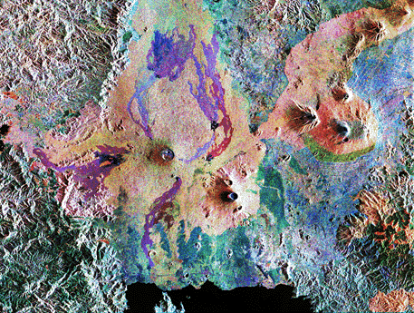
Virunga Volcano Chain -- The Virunga Volcano chain lies along the borders of Rawanda, Uganda, and the Democratic Republic of Congo (Zaire) in central Africa. This false-colored radar satellite image was acquired from the Space Shuttle Endeavor on October 3, 1994. It covers an area of 56 by 70 km. The Democratic Republic of Congo lies west of Lake Kivu (the dark, bottom of image) and Rwanda lies to the east. The steep cone in the center of the image is the Nyiragongo stratovolcano, which rises to 3,465 m (11,369 ft). The three volcanoes to the right are Mt. Karisimbi, Mt Sainyo, and Mt. Muhavura. The endangered mountain gorillas of Africa live in the bamboo forest on the southern flank of Mt Karisimbi which shows up as the green patch at the center right of the image. Courtesy of JPL/NASA. Note: See also the subaerial view of the Nyiragongo volcano. Renewed activity at Mt. Nyiragongo began on January 17, 2002. The eruption generated a 6-m-high basaltic lava flow which has advanced through the border town of Goma in the Congo. About half of the city has been destroyed and tens of thousands of refugees have fled to adjacent Rawanda. In 1977, a similar outpouring of basaltic lava killed almost 2000 people in less than half an hour. |