
 |
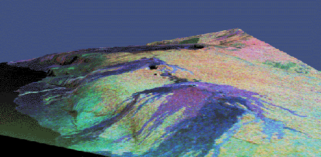
| Kilauea Volcano in 3D -- This three-dimensional perspective of the Kilauea volcano was produced using three radar frequences from the Spaceborne Imaging Radar instrument flying on the Space Shuttle Endeavor, and superimposing the radar data onto a digital elevation map. The area shown is about 34 by 57 km, with the top of the image pointing toward the northwest. The large blue region at the high center part of the image is the Kilauea caldera. The line of craters below the caldera marks the site of the Kileaua east rift system, The blue regions in the foreground are recent lava flows erupted from the Pu'u O'o and Kupaianaha volcanoes on the east rift system. Courtesy of JPL/NASA. |